


Most land buyers in Kenya do the title search, check the seller's ID, and feel they have covered the bases. Then they visit the plot to build and discover the boundary runs somewhere very different from what they were shown, or that the neighbour's fence sits well inside what they paid for. A land search tells you who owns a parcel. It does not tell you where that parcel begins and ends on the ground. That is the job of the survey plan.
Three documents that get mixed up
Buyers often use these terms interchangeably, but they do different things:
- The title deed is the legal instrument proving ownership. It carries the parcel number and basic details but does not show a detailed map of the land.
- The Registry Index Map (RIM) is an official map produced by the Survey of Kenya showing where parcels sit relative to each other within a registration block or section. Think of it as the big picture of the neighbourhood, with each plot labelled by parcel number.
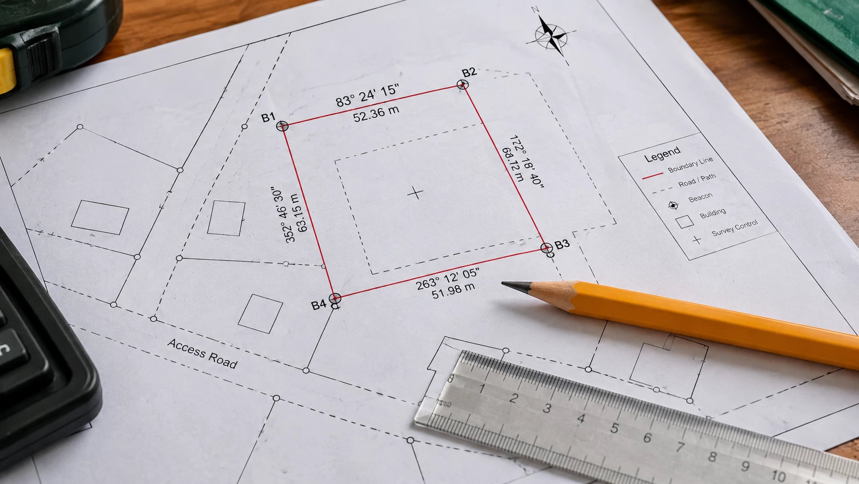
- The survey plan, sometimes called a deed plan or cadastral plan, is the detailed, parcel-specific drawing prepared by a licensed surveyor. It shows the exact boundary lengths, bearings, area, and beacon positions for one specific parcel. A survey plan is typically the surveyor's working document that gets incorporated into the RIM once the Director of Surveys approves and files it.
Survey work in Kenya is governed by the Survey Act (Cap 299), which sets out how surveys must be carried out, how beacons are recorded, and how plans are authenticated.
What a survey plan shows and how to read it
You do not need to become a surveyor, but knowing what to look for makes you far harder to mislead. A typical survey plan includes:
- Parcel identification. The parcel or LR number, along with the block or registration section and district. These must match exactly what is printed on the title deed. Even a small mismatch is a reason to stop and ask questions.
- Boundary lines with bearings and distances. Each side of the plot is marked with a length in metres and a bearing in degrees. This is what a surveyor uses to re-establish the boundary on the ground.
- Beacons. Points where boundaries change direction are marked and labelled. The Survey Act requires every beacon to be described and recorded, so each corner of your plot should appear on the plan with a reference.
- Area. Usually shown in hectares. Compare this with the size stated on your title and in the sale agreement. They should agree.
- Neighbouring parcels. Adjacent plots are shown with their parcel numbers, so you can see who your boundaries touch.
- Roads, reserves, and access. A good plan shows how the plot connects to a road and whether any road reserve, riparian strip, or other reservation cuts across it.
- North arrow and scale. Basic orientation details that let you read measurements correctly.
- The surveyor's signature and authentication. A genuine plan is signed by the licensed surveyor who prepared it and checked and authenticated by the Director of Surveys. An unsigned plan should never be accepted.
How to get the right documents
The route depends on what you need:
- A basic map extract online. Log into eCitizen or Ardhisasa, enter the title or LR number, pay the fee, and download the map. This usually costs around KSh 500 to 1,000 and gives you general location and parcel number, not detailed beacon data.
- A certified RIM extract. Visit the Survey of Kenya office or the relevant county land registry with the title number and pay the prescribed fee. For Nairobi and surrounding areas, this is typically done at the Survey of Kenya offices in Ruaraka. Any member of the public can request an extract.
- A full survey plan or beacon certificate. Engage a licensed surveyor, who retrieves the RIM, visits the site to locate the beacons, and prepares a certified plan checked by Survey of Kenya. Cost varies by surveyor and plot size, plus statutory fees.
- A certified survey plan directly from Survey of Kenya. This generally involves a folio registry number search, paying the search fee, confirming the plan exists, then paying for and collecting the plan itself.
Take the plan to the plot
Reading the document is only half the job. The other half is checking it against reality:
- Visit with the plan in hand and locate the beacons, usually metal rods or concrete markers at the corners of the plot.
- Check every corner. If all beacons are present and match the plan, that is a good sign. If any are missing, a licensed surveyor should re-establish them before you pay.
- Check the dimensions. Pace out or measure the sides and compare with the plan. Large differences point to either a mapping error or encroachment.
- Look at the neighbours. Fences, buildings, or crops sitting over the boundary line are a warning of a possible dispute.
- Hire your own surveyor. Use an independent registered surveyor, not one recommended solely by the seller, to verify boundaries and confirm the size on the ground.

Red flags to watch for
- An unsigned plan, or a hand drawn sketch passed off as a survey plan. Insist on the registered original, and confirm its plan number and status with the lands office.
- Parcel, block, or district details that do not match the title deed.
- Missing beacons, or beacons that do not match the plan.
- An area on the plan that differs from the area on the title or sale agreement.
- No clear road access shown, which can leave you with a landlocked plot.
- A road reserve, riparian strip, or other reservation cutting across the parcel, which reduces the land you can actually build on.
- A seller who resists letting your own surveyor visit the site.
How this fits with the rest of your due diligence
A survey plan is one layer of protection, not the whole thing. It works best alongside an official land search to confirm ownership and check for charges or caveats, a physical site visit, a check of the planning classification with the county, and a licensed advocate handling the transfer. If you are buying near a river or lake, the plan should also be checked against any riparian reserve, since that strip may be unbuildable even when it sits inside your title boundary.
The bottom line
A title deed proves who owns a parcel. A survey plan proves what that parcel actually is, where it sits, and how big it is. Learning to read the key details, parcel numbers that match, bearings and distances, beacon references, area, and the surveyor's authentication, takes a few minutes and protects you from some of the most common and costly land disputes in Kenya. Take the plan to the plot, check the beacons yourself, and bring in your own licensed surveyor before any money changes hands.